WATER (OCEANS)
WATER (OCEANS)
Introduction: Importance of Water and Hydrological Cycle
Water is an essential component of all life forms, and after air, it is the most important element for the existence of life on Earth. The Earth is called the “Blue Planet” because of the abundance of water on its surface. Water is a cyclic resource, continuously circulating through the hydrological cycle, which involves movement of water on, in and above the Earth in liquid, solid and gaseous forms.The hydrological cycle refers to the continuous exchange of water between oceans, atmosphere, land surface, subsurface and living organisms. About 71% of the total water is found in oceans, while the remaining exists as freshwater in glaciers, groundwater, lakes, soil moisture, atmosphere and streams. Nearly 59% of precipitation over land returns to the atmosphere through evaporation, while the rest contributes to runoff, infiltration or glacier formation.Although the total renewable water remains constant, increasing demand and pollution have led to water scarcity across regions and time.
Relief of the Ocean Floor
The oceans occupy major depressions on the Earth’s surface and form interconnected water bodies divided into five oceans – Pacific, Atlantic, Indian, Southern and Arctic. The ocean floor, located mostly between 3–6 km below sea level, exhibits complex relief similar to continents, formed by tectonic, volcanic and depositional processes.
Major Divisions of Ocean Floor
1. Continental Shelf
The continental shelf is the extended margin of continents, covered by shallow seas and gulfs. It is the shallowest part with a gentle slope (around 1° or less) and ends at the shelf break.
- Average width: ~80 km
- Maximum width: 1,500 km (Siberian Shelf)
- Depth range: 30 m to 600 m
- Covered with sediments from rivers, glaciers and winds
- Important source of fossil fuels
2. Continental Slope
The continental slope connects the shelf to deeper ocean basins.
- Gradient: 2°–5°
- Depth: 200 m to 3,000 m
- Marks the true boundary of continents
- Features include canyons and trenches
3. Deep Sea Plains
These are gently sloping, flat and smooth regions of the ocean floor.
- Depth: 3,000–6,000 m
- Covered with fine sediments like clay and silt
- Considered the flattest regions on Earth
4. Oceanic Deeps / Trenches
These are the deepest parts of oceans, characterised by steep-sided narrow basins.
- Depth: 3–5 km deeper than surrounding areas
- Located along continental margins and island arcs
- Associated with volcanic activity and earthquakes
- Total explored: 57 trenches
- Pacific: 32
- Atlantic: 19
- Indian: 6
Minor Relief Features
Mid-Oceanic Ridges
- Long chains of mountains with a central depression
- Peaks may rise up to 2,500 m
- Example: Mid-Atlantic Ridge (Iceland)
Seamounts
- Volcanic mountains rising from seafloor but not reaching the surface
- Height: 3,000–4,500 m
- Example: Emperor Seamount (Pacific Ocean)
Submarine Canyons
- Deep valleys similar to Grand Canyon
- Often extend from river mouths
- Example: Hudson Canyon
Guyots
- Flat-topped seamounts formed due to subsidence
- Over 10,000 exist in Pacific Ocean
Atolls
- Coral islands surrounding a central lagoon
- Lagoon may contain sea water or saline water
Temperature of Ocean Waters
Factors Affecting Temperature
- Latitude: Temperature decreases from equator to poles
- Land-Water Distribution: Northern Hemisphere oceans are warmer
- Prevailing Winds: Cause upwelling or accumulation of warm water
- Ocean Currents:
- Warm currents increase temperature
- Cold currents decrease temperature
Horizontal Distribution
- Average surface temperature: ~27°C
- Decreases poleward:
- 22°C at 20° latitude
- 14°C at 40° latitude
- 0°C near poles
- Northern Hemisphere oceans are warmer due to greater landmass
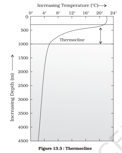
Vertical Distribution (Three-Layer System)
| Layer | Characteristics |
|---|---|
| Surface Layer | Warm, ~500 m thick, temperature 20–25°C |
| Thermocline | Rapid temperature decrease, 500–1000 m thick |
| Deep Layer | Very cold, near 0°C, extends to ocean floor |
- Thermocline: Zone of rapid temperature decline
- About 90% of ocean water lies below thermocline
- In polar regions, single cold layer exists
Salinity of Ocean Water
Salinity refers to the total dissolved salts in seawater, expressed in parts per thousand (ppt or o/oo).
- Standard ocean salinity: 33–37 ppt
- Upper limit for brackish water: 24.7 ppt
Factors Affecting Salinity
- Evaporation and precipitation
- River inflow (freshwater)
- Freezing and melting of ice
- Winds and ocean currents
Highest Salinity in Water Bodies
- Lake Van: 330 ppt
- Dead Sea: 238 ppt
- Great Salt Lake: 220 ppt
Horizontal Distribution of Salinity
- Red Sea: High salinity (~41 ppt)
- Estuaries/Arctic: Low salinity (0–35 ppt)
- Hot dry regions: Up to 70 ppt
Ocean-wise Pattern
- Pacific Ocean: Salinity decreases due to melting ice
- Atlantic Ocean: Average 36 ppt, highest between 15°–20° latitudes
- Indian Ocean: Average 35 ppt
- Bay of Bengal: Low salinity (river inflow)
- Arabian Sea: High salinity (evaporation)
Vertical Distribution of Salinity
- Salinity generally increases with depth
- Surface salinity varies due to evaporation and freshwater input
- Deep water salinity remains stable
Halocline
- Zone of rapid increase in salinity with depth
- Higher salinity → higher density → water sinks
- Leads to stratification of ocean water
Conclusion
Ocean water exhibits complex characteristics in terms of relief, temperature and salinity distribution. These variations are influenced by natural processes such as solar radiation, atmospheric circulation, ocean currents and geological activity, which together regulate the marine environment and global climate system.
MOVEMENTS OF OCEAN WATER
The movement of ocean water is influenced by temperature, salinity, density and external forces such as the sun, moon and winds. Ocean water exhibits both horizontal and vertical motions.
- Horizontal motion includes ocean currents and waves.
- Vertical motion includes tides, along with processes like upwelling (rise of cold water) and sinking of surface water.
Ocean currents involve the continuous flow of large volumes of water in a definite direction, whereas waves represent energy movement, not actual water displacement. In waves, water particles move in circular motion, while the wave form travels forward.
WAVES
Waves are the movement of energy across the ocean surface, primarily generated by wind. Wind transfers energy to water, causing waves to develop and move across long distances.As waves approach the coast, friction with the sea floor slows them down, and when water depth becomes less than half the wavelength, the waves break. The largest waves occur in open oceans, where wind energy is continuously absorbed.Wave formation depends on:
- Wind strength
- Duration of blowing
- Fetch (area over which wind blows)
Water particle movement is circular, causing upward-forward motion before the crest and downward-backward motion after passage.
Characteristics of Waves
- Crest: Highest point of the wave
- Trough: Lowest point
- Wave Height: Vertical distance between crest and trough
- Amplitude: Half of wave height
- Wavelength: Horizontal distance between successive crests
- Wave Period: Time interval between two crests
- Wave Speed: Rate of wave movement (in knots)
- Frequency: Number of waves passing per second
TIDES
Tides refer to the periodic rise and fall of sea level, occurring once or twice daily, mainly due to the gravitational pull of the moon and sun along with centrifugal force.Two tidal bulges are formed:
- One towards the moon (gravitational pull dominates)
- One on the opposite side (due to centrifugal force)
The tide-generating force is the difference between these two forces. Horizontal forces are more important than vertical ones in shaping tides.
Types of Tides
Based on Frequency
- Semi-diurnal: Two high tides and two low tides daily (most common)
- Diurnal: One high tide and one low tide daily
- Mixed tides: Variation in height (common in Pacific coasts)
Based on Sun–Moon Position
- Spring tides: Occur during full moon and new moon when sun, moon, and earth are aligned → highest tides
- Neap tides: Occur when sun and moon are at right angles → lower tidal range
Other Variations
- Perigee: Moon closest to earth → higher tidal range
- Apogee: Moon farthest → lower tidal range
- Perihelion (3 Jan): Earth closest to sun → higher tides
- Aphelion (4 July): Lower tidal range
Tidal Terms
- Ebb: Falling tide
- Flood: Rising tide
Importance of Tides
- Aid in navigation and fishing
- Help in desilting and removing pollutants
- Used for tidal energy generation
- Example: Bay of Fundy (Canada) with tides up to 15–16 m
OCEAN CURRENTS
Ocean currents are large-scale movements of water in a definite path, similar to river flow.
Forces Influencing Ocean Currents
Primary Forces
- Solar heating: Causes expansion and slight gradient
- Wind: Drives surface water movement
- Gravity: Maintains flow along gradient
- Coriolis force: Deflects currents
- Right in Northern Hemisphere
- Left in Southern Hemisphere
Secondary Factors
- Density differences(temperature and salinity)
- Cold, saline water → denser → sinks
- Warm water → lighter → rises
This leads to vertical circulation:
- Cold currents move from poles to equator
- Warm currents move from equator to poles
TYPES OF OCEAN CURRENTS
Based on Depth
- Surface currents: Upper 400 m; about 10% of ocean water
- Deep water currents: About 90% of ocean water, driven by density differences
Based on Temperature
- Cold currents
- Bring cold water into warm regions
- Found on west coasts in low latitudes and east coasts in high latitudes
- Warm currents
- Bring warm water into cold regions
- Found on east coasts in low latitudes and west coasts in high latitudes
CHARACTERISTICS OF OCEAN CURRENTS
- Measured in terms of drift (speed)
- Strongest near surface (up to 5 knots)
- Decreases with depth (<0.5 knots)
- Most currents are slow but persistent
GLOBAL OCEANIC CIRCULATION
Ocean currents follow patterns similar to atmospheric circulation:
- Middle latitudes → Anticyclonic circulation
- High latitudes → Cyclonic circulation
- Monsoon regions → Seasonal reversal of currents
These currents form large circular systems called gyres.
EFFECTS OF OCEAN CURRENTS
Ocean currents influence climate, marine life and human activities:
- West coasts (tropics/subtropics) → Cold currents → arid conditions and fog
- West coasts (higher latitudes) → Warm currents → mild climate
- East coasts (tropics) → Warm currents → warm and rainy climate
Mixing of warm and cold currents:
- Enhances oxygen supply
- Promotes plankton growth
- Creates rich fishing grounds