Biomass satellite mapping Earth’s forests in 3D with P-band SAR data
In News: Biomass Satellite – Mapping Earth’s Forests in 3D with P-band SAR (2025)
Context
- European Space Agency (ESA) flagship satellite Biomass, developed in the UK, launched from French Guiana on Vega-C rocket.
- First satellite to measure global forests in 3D using P-band Synthetic Aperture Radar (SAR).
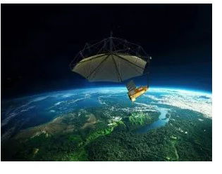
Key Features
- Orbit: 666 km altitude, mission life – 5 years.
- Payload: World’s first P-band (435 MHz) SARin space.
- Antenna size: 12m × 15m deployable radar antenna.
- Coverage: Global forests – tropical, temperate, and boreal.
- Function: Measures terrestrial carbon stocks and fluxes, monitors forest biomass loss & regrowth.
Significance
- Climate Change Policy Support – provides accurate, global-scale forest carbon data.
- Carbon Cycle Insight – improves understanding of how carbon is stored/released in forests.
- Limitations of Ground Measurement overcome – space-based system enables comprehensive monitoring.
- Global Collaboration – >50 companies, 20 nations involved.
- UK Contribution – developed by Airbus Defence & Space, Stevenage, supported 250 jobs, UK space workforce ~52,000.
India Relevance
- India is a key participant in climate action, REDD+ framework, and carbon stock accounting.
- Data from Biomass can support:
- Forest policy & afforestation programmes.
- Carbon credit markets.
- Validation of Indian Remote Sensing (IRS) missions on forest cover.
Updated - 30 April 2025 ; 10: 10 AM | https://www.electronicsweekly.com/
Biomass Satellite European Space Agency (ESA) UK Space Agency Airbus Defence & Space P-band SAR (435 MHz) 12×15m deployable antenna 666 km orbit 5-year mission carbon stocks & fluxes 3D forest mapping tropical/temperate/boreal forests climate change policy carbon cycle Vega-C rocket French Guiana launch Stevenage UK global collaboration REDD+ forest biomass loss & regrowth